| PalestineRemembered | About Us | Oral History | العربية | |
| Pictures | Zionist FAQs | Haavara | Maps | |
| Search |
| Camps |
| Districts |
| Acre |
| Baysan |
| Beersheba |
| Bethlehem |
| Gaza |
| Haifa |
| Hebron |
| Jaffa |
| Jericho |
| Jerusalem |
| Jinin |
| Nablus |
| Nazareth |
| Ramallah |
| al-Ramla |
| Safad |
| Tiberias |
| Tulkarm |
| Donate |
| Contact |
| Profile |
| Videos |
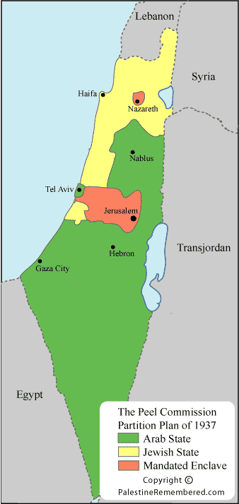
Palestine Maps: British 1937 Peel Commission Proposed Partition Plan |
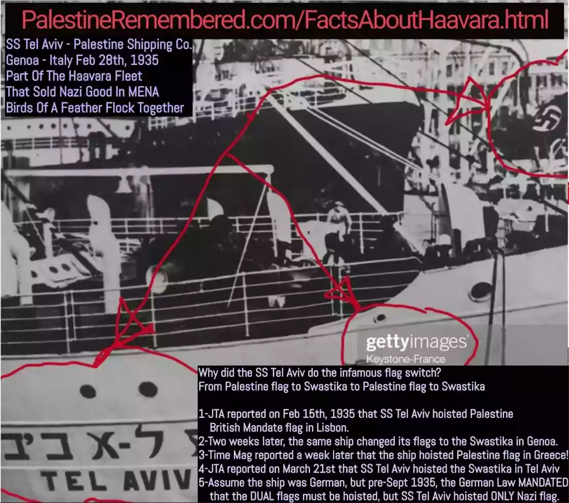 Fake Valor: Why Did Zionist Jews Hoist Nazis Flag on Their Ships in the 1930s?
What is new?
-
Facts About Oct. 7th Gaza Raid

-
Remined Us Please:: Who Did Rape Who? Palestinians Raped Israelis? Or, was the other way around?
-
When Prof. Edward Said was invited to debate Bibi Netanyahu in the 1980s, watch what happened!
-
Ezra Klein of the NY Times on the "Jewish Race".
-
Abusing Blood Libel!
-
Zionist FAQ: Isn't it true that Palestinians don't want peace? Palestinians never accepted the two-state solution
- Facts about Haavara (Transfer) Agreement between Ben-Gurion & Hitler
-
Haavara FAQs: Why Did Zionist Jews Hoist Nazis' Flags on Their Ships in the 1930s?
-
Dear ChatGPT: Gaza had a vibrant Jewish community in the mid-17th century. What happened to them?
-
Dear ChatGPT: Why did the Jewish Agency suppress news of the Holocaust during WWII?
-
Video Playlist: Jews share their DNA tests to end the conflict for good.
-
A Tale of Two Conflicts: Examining the Definition of Genocide
-
Prof. Abraham Polak And The Suppressed History of the Khazars and European Jewry
-
How Ronald Reagan would have framed the genocide in Gaza if he were still alive?
-
Haavara FAQs: Let us do the math: how many German Jews did The Haavara Agreement save?
-
Zionist FAQs: The Hebron Massacre of 1929, "clearly proves" that Palestinians are antisemitic, how could you deny it?
-
Zionist FAQs: Why Anti-Zionist Is Not Antisemitism?
-
Zionist FAQs: Isn't it true that the KGB create Palestinian Nationalism in the early 1960s?
- Zionist FAQs: Muslims are killing Muslims all the time; why are Israeli Jews being singled out in the media?
- Zionist FAQs: How is Israel an apartheid state when 20% of its citizens are Arabs who enjoy full rights?
-
Haavara FAQs: Analysis of Herzl's Uganda Scheme and how it could have saved millions of Jews.
-
Haavara FAQs: Why did Hayim Greenberg describe American Jewry as "morally bankrupt" in early 1943?
-
Haavara FAQs: What if the Evian Conference was a resounding success? What would have been the impact of saving European Jewry on Zionism?
- Haavara FAQs: What if the six million were saved, how that would have impacted the Zionist project?
-
Haavara FAQs: How did Zionist leaders react when Europe's Jews lingered in the DP camps after WWII ended?
-
Why does the American Jewish community repeat lies that David Ben-Gurion had debunked before he died?
-
Who has the power to rename the Tatar/Khazar Gene Marker to Jewish IV?
-
Zionist FAQs: Why won't Egypt, Syria, and Jordan take their people back? Jews are indigenous to Palestine, and Arabs immigrated after Jews developed the country. Arabs should leave.
-
Haavara FAQs: Did Hitler and the Nazis conflate between Judaism and Zionist? If that wasn't case, then why?
-
Haavara FAQs: Winston Churchill and antisemitism, a collection of articles written Churchill.
-
Haavara FAQs: Broken by country, how many Jews survived vs. killed during the Holocaust?
-
Haavara FAQs: Why did European Jews vote with their feet and to immigrated to the Americas, not Palestine, after WWII?
-
Watch this American Jewish Girl describing Israeli Jews' cognitive dissonance like no other in under two minutes
-
Haavara FAQs: When the Nazis went out of their way to hide the Holocaust, Israeli Jews did the exact opposite by broadcasting their genocide of Gazans. But why?
-
Haavara FAQs: How Zionist Jews went out of their to show their appreciation to Nazism and Fascism?
- Haavara FAQs: Why Zionist leaders were against bombing the death camps & the Railroads leading to them?
-
Haavara FAQs: Hitler's message to the British and American people: If Jews are such noble citizens and you care about them, how come you're not letting them in? I will gladly ship them to you at my expense, even on luxury liners!
-
A shortlist of Zionist and Israeli false flag operations in the name Jews.
-
The Most Moral Army
- The Land of Kapos (Israel): Where the brave are boycotted and Kapos walk free.
- Why did early Zionists often named their communal enterprises "colonial"?
- Zionist Relations with Nazi Germany by Faris Glubb
-
Two NY Times advertisements by Zionists in the early 1943 that exposes Zionists' treason at the height of the calamity
- Facts Not Lies about the Palestinian-Israeli Conflict.
- Site's pictures have been categorized
- Campgain Against Lice
- A Survey of Palestine, the official source about Palestine before Nakba produced by the British Mandate; over 1200 pages.
- Satellite View & Google Earth: Over 6,000 placemarks identifying all destroyed towns, W. Bank & Gaza Strip Towns, & refugee camps.
- PalestineRemembered.com and its Nakba Oral History Project were featured on al-Jazeera Satellite TV.
- Nakba Oral History Video Podcast:
 Over 700 Oral History interviews (including 3,500+ hours of recording) can be viewed online.
 - Palestine Village Statistics Project
- Gaza Jail Break
- النسخة العربية للموقع الان متوفرة
- Videos: Documenting the destroyed villages in video: Tracing all that remains since Nakba.
- Videos: Responding to Zionist Propaganda
- Interview: The ethnic cleansing of Palestine: George Galloway interviews Israeli Historian Ilan Pappe.
- For Palestinians, memory matters. It provides a blueprint for their future By George Bisharat.
- Zionist FAQ now available in Hebrew שאלות שציונים שואלים, עכשיו בעברית
- Video: The Stephen Walt and John Mearsheimer report on the influence of the Israel Lobby on U.S. Foreign Policy
- The Palestinian-Israeli conflict for beginners
Post Your Comment
*It should be NOTED that your email address won't be shared, and all communications between members will be routed via the website's mail server.
On Medinet Habu: "Medinet Habu is the name commonly given to the Mortuary Temple of Ramesses III, an important New Kingdom period structure in the location of the same name on the West Bank of Luxor in Egypt. Aside from its intrinsic size and architectural and artistic importance, the temple is probably best known as the source of inscribed reliefs depicting the advent and defeat of the Sea Peoples during the reign of Ramesses III."
Also, "c.1150 BC: Medinet Habu (temple): records a people called the P-r-s-t (conventionally Peleset) among the Sea Peoples who invaded Egypt in Ramesses III's reign."
Peleset means Philistines.
"The mortuary temple of Ramesses III at Medinet Habu depicts the victory over the Philistines who attempted to conquer Egypt:
"They were coming forward toward Egypt . . . Their confederation was the Tjeker, Shekelesh, Denye(n), Wehesh and the Peleset (Philistines)."
The Zionists are white European Khazars.
I have demonstrated via "Israeli" academic Haim Gerber (of Hebrew University in Zionist "Israel") that Palestine and Palestinians were clear territorial and citizenship terms as far back as even the Mamluks in the 13th century CE (putting aside the term going all the way back to the Romans in the 1st century CE and that the Palestinians are descendants of the original inhabitants of the land of Palestine the Canaanites aka Canaan).
One last huge point to keep in mind, "nationalism" in the modern context is a very recent phenomenon in historical terms. "Nationalism" as we know it now really only began around the 17th or 18th centuries CE in Europe. Until that time most people viewed themselves as simply part of a tribe or city not a united nation. But again even Haim Gerber refutes you, Palestine has always existed!
Also you bring forward the typical Zionist propaganda ("hasbara") claim that Palestinians allegedly didn't develop a national conscious until after the start of the European Zionist colonization of Palestine; this is demonstrably false. An "Israeli" historian (himself an "Israeli" Jew) Haim Gerber notes the reality:
Palestine and Palestinians have existed as a political entities since medieval times. As Israeli scholar Haim Gerber has noted, Palestine as a territory documented as far back as the Mamluk period in the 13th century. It was documented clearly as a political entity by the Ottomans in the later centuries. Palestine was used in Ottoman documents describe the "balad" or "ard" (Arabic for country or land) the Arab residents of the region lived in, revealing that they saw their country as Palestine and that they were Palestinians (see the work of Israeli Professor, Haim Gerber of the Hebrew University in Jerusalem has written extensively on this).
Unfortunately, the land was under the jurisdiction of the British. It was not a sovereign country of Palestine. The Zionist movement, which was established more then forty years before this plan, had a true presence in Palestine. Instead of using diplomatic means, the Palestinians (rather former Ottoman Turks) used violence against the Jews (although the Jews were not inoccent either). My point is, although the "Palestinian people" had lived on this land for a great deal of time, their nationalist movement was only developed after the introduction of Zionism. The Jews had an equal number of rights to the land, and if the plan had been accepted, well there may as well have been peace in the Middle East today...
1) The map simply did not correspond to the realities on the ground. The Jews did not own that amount of land, (purchased only about 6% by that time, though it was the highest graded land in the land), and the plan was giving them much that they simply had no right to.
2) There were also economic considerations, and these may in fact have been the most important ones.Palestine had two major revenue sources - Haifa as an industrial centre, and the orange groves in the Galilee in the North. In fact the country was dadngerously dependent on the citrus industry, as the British administration had failed to achieve any considerable investment in the rest of the country, and the inflow of capital by the Zionist side aided almost exclusively their own privileged enclave (by that time the Zionist had managed to secure a distinct economic regime in their own areas, and maintained the boycott on Arab labour). Most of the land on the Galilee however belonged to Arabs, and though the Zionists were more productive due to their use of imported technology, the Palestinian growers still produced the majority. If you notice now, the map grants to the Jews Haifa, was to remain in Jewish jurisdiction in the small Arab enclave, and the entirey of the Galilee, which also possessed the best land. The image for the Palestinian side is misleading. A large amount of the land in the Palestinian state is simply the Negev, which is a dessert, while the Eastern Areas are the hilly country, which is less suitable for cultivation. The Palestinian state would be destined for impoverishment.
3) But another very important factor which the map does not reveal, was that the Peel proposals called for forced transfer of the Arabs living in the area to be the Jewish state, a forced transfer of more than a hundred thousand. This was of course completely unacceptable to the Palestinians
That's why.